Search Panel
CoastWatch News
| Title | Summary | Date Posted | Category |
|---|---|---|---|
New release of CoastWatch Utilities software (v4.1.5)
Jan 14, 2026 |
Announcement NOAA CoastWatch Central Operations Now Distributing the CoastWatch Utilities Version 4.1.5 software |
Announcement | |
Possible service interruption January 20th 1200 -1700Z
Jan 14, 2026 |
Announcement Maintenance is planned for Tuesday, January 20, 2026. |
Announcement | |
| Switch from Himawari-8 to Himawari-9
Nov 21, 2025 |
Announcement NOAA CoastWatch plans to resume production of Himawari-9 Imagery and Derived Products starting on November 26th, 2025. This follows an announcement from Japan's Meteorological Agency (JMA), who confirmed a successful technical restoration of the satellite. |
Announcement | |
| Possible disruptions in ASCAT wind and SEVIRI SST products
Sep 11, 2025 |
Announcement Due to system maintenance, the Meteosat-11 SST and MetOP Wind products may experience delays in processing beginning September 11, 2025. |
Announcement | |
NOAA CoastWatch Sentinel-1C data availability
Aug 20, 2025 |
Announcement NOAA CoastWatch has added Sentinel-1C (S1C) Normalized Radar Cross Section (NRCS) data to its data portal. |
Announcement | |
| Product Availability
Jun 17, 2025 |
Announcement See our news item for which NOAA CoastWatch data products are unavailable or experiencing increased latency. |
Announcement | |
| 2025 CoastWatch Annual Meeting Apr 30, 2025 |
Announcement The 2025 CoastWatch Science Meeting will take place next week May 5-8, 2025 and is hosted by the NOAA CoastWatch PolarWatch Node and the Geophysical Information Network of Alaska (GINA) at the University of Alaska-Fairbanks. |
Announcement | |
GOES-19 SST from ACSPO v3.0 has been released for experimental, best effort, public distribution 
Apr 16, 2025 |
Announcement G19 SST data quality is ready for best effort, public distribution. |
Announcement | |
| 2025 CoastWatch Annual Science Meeting Goes Virtual Apr 7, 2025 |
Announcement 2025 CoastWatch Annual Science Meeting in Fairbanks, Alaska, now virtual. |
Announcement | |
CoastWatch Utilities Version 4.0.1 Released
Feb 4, 2025 |
Announcement CoastWatch Utilities Version 4.0.1 is now available |
Announcement | |
| Sea Surface Temperature Survey
Nov 22, 2024 |
Announcement Open invitation to complete a short survey about your current and future needs for Sea Surface Temperature (SST) products so that NOAA can best determine the future direction for these products |
Announcement | |
| Ocean Heat Content Survey
Nov 22, 2024 |
Announcement Open invitation to complete a short survey about your current and future needs for Ocean Heat Content (OHC) products so that NOAA can best determine the future direction for these products |
Announcement | |
| NOAA Operational ACSPO SST L3S Day/Night AM/PM product suite
Oct 1, 2024 |
Announcement https://coastwatch.noaa.gov/data/pub0053/coastwatch/sst/l3s/ |
Announcement | |
New experimental mesoscale eddy products
Sep 3, 2024 |
Announcement The sea surface height team in NOAA’s Laboratory for Satellite Altimetry developed two experimental mesoscale eddy products: Multiparameter Eddy Significance Index (MESI) MUltiparameter NRT System for Tracking Eddies Retroactively (MUNSTER) |
Announcement | |
Hardware issues result in inaccessible data
Aug 26, 2024 |
Announcement Data access has been restored. |
Announcement | |
| Sea surface temperature processing issues
Aug 15, 2024 |
Announcement Sea surface temperature processing of ACSPO FRAC L2P/L3U and L3S products has been suspended due to ongoing maintenance beginning August 12, 2024. |
Announcement | |
CoastWatch data distribution issues (update #1: 08 July 2024)
Jul 1, 2024 |
Announcement NOAA CoastWatch is working hard to restore data distribution due to failed hardware over the weekend of 29-30 June 2024 |
Announcement | |
| S-NPP GPS and data geolocation issue
May 30, 2024 |
Announcement Starting on May 25 at ~22:30 UTC, the GPS on the S-NPP spacecraft toggled to invalid causing the geolocation of all observed data to be inaccurate and out of the mission specifications. |
Announcement | |
| Geomagnetic storm affected the quality of the Sea Level Anomaly product
May 17, 2024 |
Announcement The recent geomagnetic storms (May 11, 2024) caused temporary degradation of the near real-time sea surface height products. (The wave height and wind speed products had little if any impacts). This includes the gridded daily sea level anomaly product. |
Announcement | |
Monitoring water clarity on Cape Cod with satellite imagery: CoastWatch-led study 
May 7, 2024 |
User Story CoastWatch researchers recently collaborated with scientists in Massachusetts to study the feasibility of using satellite data to monitor water clarity in Cape Cod. |
User Story | |
NOAA CoastWatch distribution of 'Legacy' SST to be discontinued
Apr 29, 2024 |
Announcement NOAA CoastWatch 'legacy' sea surface temperature products will no longer be distributed through CoastWatch as of July 1, 2024. |
Announcement | |
| Ocean Color data affected by Eclipse
Apr 10, 2024 |
Announcement The total solar eclipse that stretched across much of the United States on April 8, 2024 can be seen in several optical satellite remote sensing products. |
Announcement | |
| Dr. Betty Staugler Honored with Eponymous Species
Mar 22, 2024 |
Announcement A newly-identified algal species was named for Betty Staugler, a CoastWatch team member |
Announcement | |
| CoastWatch Annual Science Meeting 2024 Agenda
Mar 13, 2024 |
Announcement Announcing the tentative agenda for the 2024 Annual Science Meeting |
Announcement | |
| GeoXO Town Hall at the Ocean Sciences Meeting on Feb 20
Jan 23, 2024 |
Announcement CoastWatch and colleagues will be leading a Townhall at AGU OSM on February 20 at 12:45 CST. |
Announcement | |
| Registration Open: Satellite Training Course, Micronesia, March 25-29
Jan 23, 2024 |
Announcement CoastWatch is hosting a virtual training class aimed towards Micronesian users, but is open to all. |
Announcement | |
| Changes in Ocean Heat Content products
Jan 23, 2024 |
Announcement The Ocean Heat Content product produced by the Office of Satellite Products and Operations has been updated for cloud processing resulting in a change to the filename and underlying metadata. |
Announcement | |
| CoastWatch Annual Science Meeting Registration Jan 18, 2024 |
Announcement Register now for the 2024 CoastWatch Annual Science Meeting in College Park, MD. |
Announcement | |
Noticeable shift in select 4km global datasets
Oct 17, 2023 |
Announcement Update: October 17, 2023 The cause of the shift in data appears to be due to a version change of an underlying mapping program |
Announcement | |
| New Hurricane Tool in Development Oct 13, 2023 |
Announcement AOML, CIMAS, and CoastWatch have developed an initial version of a hurricane-ocean database and display for all Atlantic tropical cyclones during 2003-2022 |
Announcement | |
| Save the Date: 2024 Annual Meeting Oct 6, 2023 |
Announcement The NOAA CoastWatch Program has set the dates for its 2024 Annual Meeting |
Announcement | |
| NOAA-21 reaches Provisional Maturity for SST Sep 12, 2023 |
Announcement The Joint Polar Satellite System (JPSS) has approved NOAA-21 Visible Infrared Imaging Radiometer Suite (VIIRS) Advanced Clear Sky Processor for Ocean (ACSPO) sea surface temperature (SST) products for Provisional Maturity |
Announcement | |
| Planned termination of NOAA NRT MODIS SST products
Sep 12, 2023 |
Announcement Due to a degraded performance of Aqua and Terra Moderate Resolution Imaging Spectroradiometer (MODIS), which both currently fly in unstable (not corrected) orbits, NOAA near real-time processing of MODIS sea surface temperature (SST) products will be sunset in approximately 15 days. |
Announcement | |
| Upcoming ACSPO SST Filename change
Sep 12, 2023 |
Announcement The NOAA Advanced Clear-Sky Processor for Ocean (ACSPO) L3S-LEO-PM and L3S-LEO-DY products will be updated from ACSPO v2.80 to ACSPO v2.81 on October 2, 2023. The updates from V2.80 are: |
Announcement | |
| 2023 Annual Meeting Report
Aug 24, 2023 |
Event Summary Linked here is a brief report from the 2023 CoastWatch Annual Meeting, held in Honolulu from May 22-25. Those outside of NOAA may request access. |
Event Summary | |
| CoastWatch Annual Meeting - May 2023
Jun 7, 2023 |
Event Summary The 2023 CoastWatch Annual Meeting was hosted by the OceanWatch-Central Pacific node on May 22-25 in Honolulu, Hawaii. |
Event Summary | |
| Registration Open: Satellite Training Course, Alaska, Sept 18-20
May 19, 2023 |
Announcement Registration for the next CoastWatch Satellite Training Course is open. This is a hybrid class hosted in Alaska by PolarWatch |
Announcement | |
| Registration for OSOS-3 Closes May 12
May 10, 2023 |
Announcement Registration closes on Friday May 12 for the Third International Operational Satellite Oceanography Symposium (OSOS-3). OSOS-3 will be held June 12-16, 2023, in Busan South Korea. |
Announcement | |
| Sentinel-3 Data Outage
May 2, 2023 |
Announcement EUMETSAT has notified us that data remain unavailable until further notice due to a ground systems issue. This affects all products from both Sentinel-3 spacecraft which host the following sensors: SLSTR, OLCI, and SRAL. |
Announcement | |
Sargassum FAQ
Apr 4, 2023 |
User Story A Frequently Asked Questions (FAQs) for Sargassum was composed by the NOAA Atlantic Oceanographic & Meteorological Laboratory (AOML) in partnership with NOAA CoastWatch Caribbean, Gulf of America, and Atlantic OceanWatch Node. |
User Story | |
| Delays in Sentinel-3A/B products
Mar 30, 2023 |
Announcement Data and products from Sentinel-3A/B OLCI/SLSTR/SRAL will be delayed due to back-end issues. Work is in progress to restore the data flow and a catch-up delay will also be incurred. We hope to have a nominal state by Saturday April 1, 2023. Thank you for your patience as we work to restore this service. |
Announcement | |
| Update/change to NCEI Blended Winds product metadata
Mar 29, 2023 |
Announcement The NCEI Blended Winds product metadata has been updated. Please review these changes. |
Announcement | |
C-HARM: Predicting Harmful Algal Blooms with Satellite Data
Mar 14, 2023 |
User Story The West Coast Node (WCN) of CoastWatch is home to thousands of datasets; from ACSPO SST to Vector Winds, their ERDDAP server stores decades of historic climate data. But one group of products stands out with its impact on the coastal communities of California and Southern Oregon: C-HARM. |
User Story | |
| NOAA CoastWatch Annual Science Meeting 2023
Feb 28, 2023 |
Announcement This year's NOAA CoastWatch Annual Science Meeting will be hosted by OceanWatch Central Pacific Node (OWCP; housed in NMFS/PIFSC). The meeting will be held at the Imin Conference Center (part of the East-West Center) on the campus of the University of Hawaiʻi at Mānoa in Honolulu, Hawaiʻi. The location of the annual meeting rotates regionally, and such a meeting occurs in the US Pacific Islands region approximately once every 12 years. |
Announcement | |
| Job Opportunity at University of Maryland - Apply by March 15
Feb 27, 2023 |
Announcement The Cooperative Institute for Satellite Earth System Studies (CISESS) of the University of Maryland is currently recruiting a Global Sea Surface Temperature Scientist. |
Announcement | |
| CoastWatch Central ERDDAP Planned Maintenance
Jan 3, 2023 |
Announcement The CoastWatch ERDDAP will undergo maintenance on January 5, 2023. Datasets may be unavailable through this service for up to 24 hours. The ERDDAP is expected to resume normal operations on January 6, 2023. Please use alternate access points (HTTPS, THREDDS) for data during this time. |
Announcement | |
| 2022 Status of U.S. Marine and Great Lakes Ecosystems Released
Dec 15, 2022 |
Announcement The Ecosystem Indicator Working Group (EIWG) has released an update of the National Marine Ecosystem Status website, which provides easy access to NOAA’s wide range of important coastal and marine ecosystem data. The website provides a holistic view of important ecosystem data and has been newly expanded to the Great Lakes in 2022. New indicators such as the number of days an ecosystem experiences a marine heatwave and changes in the distribution of species have also been added. |
Announcement | |
| OSOS-3 Abstract Deadline Extended
Dec 1, 2022 |
Announcement The call for abstracts and registration for the Third International Operational Satellite Oceanography Symposium (OSOS-3) are open! OSOS-3 will be held June 12-16, 2023, in Busan South Korea. The abstract submission deadline has been extended to December 11, 2022. The registration deadline is May 12, 2023. |
Announcement | |
| Call for Abstracts: OSOS-3
Nov 14, 2022 |
Announcement The call for abstracts and registration for the Third International Operational Satellite Oceanography Symposium (OSOS-3) are now open! OSOS-3 will be held June 12-16, 2023, in Busan South Korea. The abstract submission deadline is November 26, 2022, registration deadline is May 12, 2023. Abstract submission instructions, online registration, and additional information can be found on the meeting website. |
Announcement | |
| NOAA CoastWatch Gulf of America / Caribbean Node Service Restored
Oct 31, 2022 |
Announcement Update (Oct 31, 2022): Services restored |
Announcement | |
| NOAA-15 AVHRR Scan Motor Issue
Oct 28, 2022 |
Announcement NOAA-15 AVHRR scan motor has been having issues. NOAA CoastWatch recommends using other spacecraft and ACSPO products (like the new daily L3S global 2km product) for your sea surface temperature needs. |
Announcement | |
| Third International Operational Satellite Oceanography Symposium
Sep 16, 2022 |
Announcement The Executive Steering Committee is pleased to invite community members from all levels of the value chain, from data providers to users of operational satellite oceanographic data, products and applications, to attend the third international Operational Satellite Oceanography Symposium (OSOS-3). This Symposium will be held in-person with limited online viewing access (not fully hybrid). We will feature research in Asia and the Pacific, and high latitude. |
Announcement | |
| Atlantic OceanWatch Assisting FEMA as Sargassum Reaches Record Levels in Caribbean Aug 8, 2022 |
User Story Node Managers Dr. Goni and Dr. Trinanes are participating in the USVI/Sargassum Emergency FEMA Workshop in St. Croix |
User Story | |
| S-NPP/VIIRS instrument in safe-mode
Jul 28, 2022 |
Announcement The SNPP spacecraft entered a non-nominal state at ~16:24:49 UTC on July 26, 2022, after which all SMD and telemetry data was inaccessible. While the root cause continues to be investigated, subsequent contacts have confirmed the spacecraft and all instruments are currently in a safe mode state. Engineering will continue to restore all instruments and science data to an operational state once a plan forward has been determined. All missed data will not be recoverable. The NOAA-20 spacecraft will continue to provide all the primary JPSS science data needs. |
Announcement | |
| New version of CoastWatch Utilities released (v3.7.1 b1230)
Jul 26, 2022 |
Announcement Version 3.7.1 b1230 of the CoastWatch Utilities has been released. Updates include: |
Announcement | |
Predicting Vibrio Risk Using Satellite Data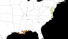
Jul 22, 2022 |
User Story As sea temperatures rise, lethal Vibrio bacteria species populations are growing. The NOAA CoastWatch Caribbean and Gulf of America regional node at AOML has developed a model to predict Vibrio habitat suitability on a global scale. |
User Story | |
| Upcoming AMS Short Course co-instructed by Great Lakes Node manager
Jul 15, 2022 |
Announcement Dr. Andrea VanderWoude, the NOAA CoastWatch Great Lakes Node Manager, will be one of the co-instructors for the upcoming AMS Joint Satellite Lake Data and Products Short Course, August 7, 2022, This is a hybrid event with both in-person and remote attendance available. |
Announcement | |
| New three-sensor DINEOF global, 9 km, gap-filled ocean color products Jun 27, 2022 |
Announcement Multi-sensor 9 km ocean color products are now available on the data portal and ERDDAP. These global gap-free data come from 3 instruments: the VIIRS sensor aboard both SNPP and NOAA-20, plus the OLCI on Sentinel 3A. The OLCI Level-1B data are from EUMETSAT, and VIIRS Level-1B data are provided by NOAA, JPSS. The NOAA/STAR Ocean Color Team then produce the chlorophyll, light attenuation (downwelling) at 490 nm (Kd490), and Suspended Particulate Material (SPM) analysis products on a ~10 day delay. |
Announcement | |
| Data unavailability update
Jun 27, 2022 |
Announcement Most data streams and services have been restored. S-3A/B Level-2 OLCI data are still undergoing consolidation. Broken links may appear for retrospective data during this transition. Contact coastwatch.info@noaa.gov if you need assistance in locating data. |
Announcement | |
| CoastWatch Tools and Data Featured in Undergraduate Courses May 26, 2022 |
User Story Dr. Sherry Palacios from CSUMB utilizes CoastWatch ERDDAP, Data Portal, and training materials in her oceanography curricula. |
User Story | |
| CoastWatch Annual Science Meeting - May 2022
May 12, 2022 |
Event Summary From May 9 - May 12, 2022, CoastWatch hosted their hybrid Annual Science Meeting, the first since the onset of the pandemic. 91 participants registered to attend, with most participating virtually and up to 25 attendees in person at the NOAA Center for Weather and Climate Prediction (NCWCP) Building on the University of Maryland Campus in College Park, Maryland. The majority of attendees were NOAA affiliates or federal employees, though members of academia, representatives of non-government organizations, and state/local government workers also participated. |
Event Summary | |
Hunga Tonga–Hunga Ha'apai Eruption
Apr 1, 2022 |
Gallery Images Visible satellite images taken during the Hunga Tonga-Hunga Ha'apai eruption that occured on Jan. 15, 2022. |
Gallery Images | |
| New Arctic 1km Synthetic Aperture Radar Composite Mar 31, 2022 |
Announcement The NOAA STAR (Center for Satellite Applications and Research) Water Surface Conditions/Sea Surface RoughnessTeam has developed an arctic normalized radar cross section (NRCS) daily composite from multiple spacecraft synthetic aperture radar (SAR) instruments at 1km resolution. |
Announcement | |
Predicting Winter Weather in Michigan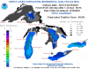
Mar 23, 2022 |
User Story Forecasters at the Grand Rapids Weather Forecast Office describe how they use CoastWatch data to predict lake effect snow, freezing spray, and more. |
User Story | |
Predicting Lake Ice Drifts in Cleveland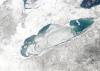
Mar 23, 2022 |
User Story Meteorologists at the Cleveland Weather Forecast Office tell a story exemplifying how CoastWatch data supports their mission, and how accurate predictions can save lives. |
User Story | |
Sentinel-2 Maximum Chlorophyll Index (Experimental)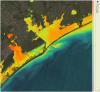
Oct 28, 2021 |
Gallery Images | Gallery Images | |
| CoastWatch Annual Science Meeting - September 2021
Oct 7, 2021 |
Event Summary The CoastWatch / OceanWatch / PolarWatch Program (CW / OW / PW) held its annual science meeting September 27-30, 2021, hosted virtually by the East Coast Regional Node. The meeting was a chance for the six regional nodes and the CW/OW/PW Central Operations team to convene with data users and scientists on the progress of current projects, the needs of the user community, new satellite data products including those from upcoming satellite missions, and the status of applications and tools for meeting environmental concerns. |
Event Summary | |
Cumbre Vieja Volcanic Eruption
Sep 28, 2021 |
Gallery Images | Gallery Images | |
A Satellite's View of Coastal Erosion
Sep 23, 2021 |
User Story One expected impact of climate change is an increase in the frequency and severity of storms in the eastern United States. As such, many coastal communities and ecosystems are increasingly vulnerable to the detrimental impacts of coastal erosion. The CoastWatch East Coast node monitors coastal erosion by tracking in-water sediment values. |
User Story | |
Zachary Paolillo - Graduate Student
Sep 23, 2021 |
Student Spotlight Graduate assistant Zachary Paolillo worked to support NOAA CoastWatch communications efforts. During his time at NOAA, Zach worked on producing outreach and training materials including compiling examples of how NOAA CoastWatch data are used and a tutorial for analyzing satellite data with ArcGIS. |
Student Spotlight | |
Gulf of America Loop Current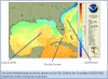
Sep 23, 2021 |
User Story The Gulf of America loop current brings warm Caribbean water northward between the Yucatan Peninsula and Cuba and into the Gulf. The current loops around the Gulf, flows southeastward into the Florida Strait where it serves as a parent to the Florida current and ultimately joins the Gulf Stream. |
User Story | |
India Oliver - Undergraduate Student
Sep 23, 2021 |
Student Spotlight This summer, NOAA CoastWatch/OceanWatch/PolarWatch hosted undergraduate summer intern, India Oliver, as part of an undergraduate scholarship program run through NOAA’s Educational Partnership Program with Minority Serving Institutions. |
Student Spotlight | |
Ocean acidification in the Caribbean
Sep 23, 2021 |
User Story In collaboration with the NOAA Atlantic Oceanographic and Meteorological Laboratory's Ocean Chemistry and Ecosystems Division and NOAA Coral Reef Watch, the Caribbean/Gulf of America node of CoastWatch produces an ocean acidification product suite for the greater Caribbean region to track changes in the surface ocean that can be used as an important tool in coral reef research and management. |
User Story | |
The Tongue of the Ocean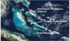
Sep 23, 2021 |
User Story The Tongue of the Ocean is a deep water basin in the Bahamas that is surrounded to the east, west and south by a carbonate bank known as the Great Bahama Bank. The deep blue water of the Tongue is a stark contrast to the shallow turquoise waters of the surrounding Bank. |
User Story | |
Saharan Dust and its Impacts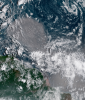
Sep 23, 2021 |
User Story Winds blowing across the Sahara Desert send large clouds of dust that travel thousands of miles to the Atlantic Ocean or Mediterranean Sea. The growth of phytoplankton, microscopic plants at the base of the ocean food chain, is restricted by iron availability. When Saharan dust is blown into the ocean, phytoplankton use the iron and nutrients from the dust and begin to grow and reproduce. |
User Story | |
Detecting Sea Level Anomalies with Satellites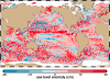
Sep 23, 2021 |
User Story By studying sea level anomalies, scientists can improve understanding of ocean circulation patterns and improve forecasts of climatological events such as El Niño and La Niña. The NOAA Laboratory for Satellite Altimetry produces daily near-real time global sea level anomaly datasets from a constellation of radar altimeter missions. |
User Story | |
Improving Satellite Sea Surface Temperature Analysis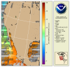
Sep 23, 2021 |
User Story Information about sea surface temperature is important for weather and ocean forecasting, climate monitoring, military and defense operations, ecosystem assessment, fisheries analyses and tourism operations. NOAA's Sea Surface Temperature Team is working to improve their products by reanalyzing past data with NOAA's Advanced Clear-Sky Processor for Oceans (ACSPO) using the enterprise algorithm. |
User Story | |
Colors and Confusion: Making Better Color Choices for Data Visualization
Sep 23, 2021 |
User Story Communication of scientific information and data to the public is part of NOAA’s mission, and scientific visualization is often the public’s first encounter with the agency’s data. This post gives an overview of recent advances and considerations for selecting and improving color selection for remote sensing data. NOAA CoastWatch will be experimenting with different colors for its data presentations. |
User Story | |
Monitoring Sea Surface Winds and Sea Ice with Satellite Radar
Sep 23, 2021 |
User Story Synthetic Aperture Radar (SAR) is an active radar satellite instrument that transmits microwave pulses that bounce off the Earth’s surface. The radar signals are then processed into imagery that can be used to derive several geographic and non-geographic features including: wind speeds, oil spills, sea ice and ship detection. |
User Story | |
Annotated Ocean Color from VIIRS
Sep 1, 2021 |
Gallery Images | Gallery Images | |
Booklet: Advanced techniques for monitoring water quality using Earth Observation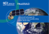
Oct 19, 2019 |
User Story AquaWatch, the Group on Earth Observations (GEO) Water Quality Initiative, presents information about water quality issues and monitoring in a variety of habitats and exemplars of water quality monitoring using archived and next generation Earth Observation data using technologies developed and exploited by researchers within the AquaWatch community. |
User Story | |
NOAA researchers review approaches to satellite-derived coastal water quality products![Scientific Figure showing contributions of phytoplankton(link is external), CDOM, and nonalgal particulate(link is external) absorption coefficients(link is external) to total non-water absorption for waters with relatively (a) higher and (b) lower degrees of correlation between [Chl-a] and Rrs(490)/Rrs(555)](sites/default/files/styles/thumbnail/public/2022-12/1-s2.0-S0079661116302592-gr13a358.jpg?itok=QIc2gStc)
Oct 16, 2019 |
User Story In a paper published in 2017 in Progress in Oceanography, coauthors Guanming Zheng and Paul M. DiGiacomo reviewed approaches to deriving water quality products from satellite ocean color data. They quantify and discuss the inherent uncertainties surrounding the characterization of water quality parameters of interest in coastal waters |
User Story | |
Temperature Climate Indicators of Estuaries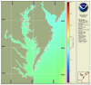
Jul 11, 2019 |
User Story The National Estuary Program identifies, protects, and conserves water quality for ecologically significant estuaries and surrounding watersheds. The National Estuary Program uses Sea Surface Temperature time series products produced by the NOAA CoastWatch East Coast Node for estuary management. |
User Story | |
Great Lakes Quarterly Climate Impacts and Outlook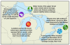
Mar 20, 2019 |
User Story U.S. and Canadian Great Lakes agencies work together to document significant quarterly events, seasonal and yearly changes for the Great Lakes region and compile them into quarterly reports. NOAA Great Lakes CoastWatch data used in these bulletins includes Sea Surface Temperature, Synthetic Aperture Radar and real time marine data from buoys, coastal met stations, airports, and ships. |
User Story | |
Ice Breaking Operations and Shipping in the Great Lakes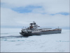
Mar 20, 2019 |
User Story In order to understand ice formation and the types of ice in the Great Lakes, the NOAA Great Lakes Environmental Research Laboratory (GLERL) and the U.S. Coast Guard use Synthetic Aperture Radar (SAR) data from the NOAA CoastWatch Great Lakes Node to monitor six different types of ice, ice thickness, and ice cover. |
User Story | |
Tropical Cyclone Heat Potential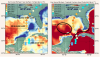
Mar 20, 2019 |
User Story NOAA's Atlantic Oceanography & Meteorological Laboratory produces a Tropical Cyclone Heat Potential (TCHP) product represents a robust measure of how much energy is available in the ocean to sustain or modify the intensity of tropical cyclones.The NOAA CoastWatch Geo-Polar Blended surface sea temperature product and sea surface height data are used to produce global daily TCHP fields. |
User Story | |
Identifying Climate-Driven Shifts in Jumbo Flying Squid Fishing Grounds
Feb 15, 2019 |
User Story The jumbo flying squid (Dosidicus gigas), also known as the Humbolt squid, is an economically important fisheries species in the Eastern Pacific, currently accounting for approximately one third of the world's squid landings. Sea surface temperature and sea surface height data from NOAA OceanWatch Central Pacific node was used to research movements of their fishing ground. |
User Story | |
Harmful Algal Bloom Monitoring and Forecasting in the Gulf of America
Feb 15, 2019 |
User Story NOAA's National Ocean Service uses CoastWatch ocean color data along with cell counts and other environmental information to produce a Harmful Algal Blooms Observing System (HABSOS) and a Harmful Algal Bloom Operational Forecast System (HAB-OFS). |
User Story | |
Juvenile Salmon Shark Habitat Use Research
Feb 15, 2019 |
User Story Standings of small juvenile salmon sharks have been reported between British Columbia, Canada and northern Baja California. A recent study used CoastWatch sea surface temperature data from the west coast regional node to explore the link between salmon shark strandings and water temperature. |
User Story | |
TurtleWatch: A Tool for Reducing Loggerhead Turtle Bycatch
Feb 15, 2019 |
User Story Fisheries bycatch has been implicated as a contributing factor in the population decline of endangered Pacific loggerhead turtles. In order to reduce interactions between longline fishing vessels based in Hawaii and loggerhead sea turtles, the NOAA Pacific Islands Fisheries Science Center created an experimental information product called TurtleWatch. |
User Story | |
EcoCast: A tool to help fishers minimize bycatch off the US West Coast
Feb 15, 2019 |
User Story The EcoCast tool uses habitat suitability models and satellite-derived environmental data to predict where broadbill swordfish and three bycatch species (leatherback turtle, blue shark and California sea lion) are likely to be each day. Daily EcoCast maps help fishers identify fishing spots minimize fisheries bycatch and maximize fisheries target catch. |
User Story |